
400,000 Shanghai friends are watching ↑
Cooperation contact QQ: 1928382886
Picture and text transferred from: Shanghai News (news310)
Huangpu RiverBaoshan Binjiang, Shanghai's Mother River
It not only carries Shanghai's profound cultural history
Both sides of the Yangtze River are also good places for leisure, fitness, and sightseeing
and then
Both sides of the Pujiang River will increase the construction and opening of public space
by the end of next yearBaoshan Binjiang, from Yangpu Bridge to Xupu Bridge
45 kilometers of public space will be open
Huangpu Binjiang
The total length of the coastline of the Binjiang Huangpu section is about 8.3 kilometers
The land area is about 3 square kilometers
It is an important area for Shanghai to implement the "Four Centers" strategy
Riverside Shoreline Planning in Huangpu District
"Five-Road Integration" slows down along the riverside

By the middle of next year, the Huangpu Riverside coastline
will extend south from the Bund
With the Bund, South Bund, and Expo Park
8.3 Kilometers of public space are fully connected
By increasing the width of sidewalks and non-motor vehicles
Improve the integrated transportation system that integrates water and land
"Leisure walking track, fitness jogging track, bicycle cycling track, land sightseeing track, water sightseeing boat track"
Integration of five ways and strive to create
Integrate sightseeing, leisure, fitness and other functions
Create a classic slow life
Please watch the video on WiFi
Xuhui Riverside
In the past, it was difficult for you to connect Xuhui and Huangpu River
Because for a long time
The entire area along the Yangtze River is occupied by industrial bases and transportation land
Cement factory, oil depot, Beipiao Wharf
Even the railway station, Longhua Airport, etc. have once taken root here
It is impossible for ordinary citizens to approach the Huangpu River
However, the latest Xuhui Riverside design plan is being solicited
Mr. Peter, Master Planning Master of P.D. R Company in the UK, and his team
The concept of "Shanghai CORNICHE" proposed
makes people shine
■ Mr. Peter's planning ideas for Binjiang cornhe (hand-drawn draft)
The 8.4-kilometer-long coastline along the Yangtze River is divided into three sections
(Leisure and cultural area, art and cultural area, nature experience area)
Four routes (leisure trails, waterfront trails, bicycle leisure trails, reserved tram)
Whether driving or walking
You can find nearby parking lots through intersection nodes
Or cross the street through sidewalks, flyovers, underpasses, etc.
Enter the riverside open space
■ Three paragraphs/four moving lines/multiple nodes
future
Beipiao Wharf will be transformed into Dragon Art Museum
Shanghai aircraft manufacturing plant
Will be transformed into a West Bank Cultural and Art Demonstration Zone
Cement factory will transform into Shanghai Dream Center
Old workers can find good memories of the past here
Young people can find a familiar novelty here
This is their shared history and feelings
Yangpu Riverside
Yangpu Binjiang is the most representative birthplace of industrial civilization in Shanghai and even the country
The riverside scenery line currently open to the public is about 500 meters long
Public open space is approximately 26800 square meters
Located on Yangshupu Road (Dandong Road-Huaide Road)
Close to the North Bund area
Connected with Lujiazui Financial District, North Bund, and Shipping Center
Yangpu divides the riverside into three sections
The southern section of Binjiang River runs from Qinhuangdao Road to Dinghai Bridge;
The middle section of Binjiang River is the entire Fuxing Island;
The northern section of Binjiang is along Jungong Road
During the Thirteenth Five-Year Plan period
Yangpu will comprehensively develop and build the southern section of Binjiang River
Complete full coverage of the detailed control plan for the central and northern section of Binjiang River
Retain old industrial elements as much as possible
Absorbing the design concept of "Sponge City"
Achieve rainwater reuse
Hongkou Binjiang
Hongkou North Bund is close to Huangpu River
There is also the Hongkou Port water system running through it
It is the central Urban area with the richest water resources
In the future, the North Bund will be on three levels of the riverside
That is, the core business district is planned to form a "green street in the sky"
Gradually connect Shanghai Music Valley, Sichuan North Road Commercial Street and other Hongkou hinterland
Form a "one horizontal and one vertical" continuous landscape riverside corridor
Plan the "Green Street in the Sky"
East to Xinggang International Center
West to Bailulan Square
Heading south straight to the riverside green space
At present, the riverside public green space has been opened to the public
At the same time, the public green space in front of the International Shipping Service Center
Construction is also being stepped up
According to the plan, the North Bund is divided into four major blocks
The core area of the North Bund is mainly a business and cultural district
Zhoushan Road is planned as a historical and creative district
Water-friendly leisure districts will be built near Hongkou Port, including the Music Valley area
Suzhou River Estuary Lehuo Commercial District
These four major neighborhoods are connected by "green streets in the sky"
Open-air activity space will be provided for citizens
what is expected is
A waterfront slow-moving system that runs directly from the Huangpu River to the hinterland of Hongkou will also be unveiled
This waterfront trail centers on Music Valley
Citizens can start from the starting point of Hengbang Bridge on Sichuan North Road
Follow Yujingpu to Shanghai Music Valley
From Music Valley, follow Hongkou Port to the North Bund Riverside Green Space
In the past, tourists walked from the Bund to Waibaidu Bridge and turned back
There seems to be an invisible chasm between the North Bund and the Bund
Wait until the Yangtze River Wharf realizes functional replacement
The North Bund will form a continuous public open space belt along the Huangpu River
Pedestrian bridge through Suzhou River Estuary
The North Bund and the Old Bund Riverside Space will be integrated
According to the plan, multiple corridors will be built along Dongchangzhi Road in the future
Not only air connectivity, but also underground connectivity
An underground passage has been reserved at the International Passenger Transport Center Station of Line 12 to connect the underground floor of Bailulan Plaza on the North Bund
After the completion of the passage between Magnolia Square and the first-line riverside
It will become more convenient for citizens to approach the beautiful scenery of the riverside
Pudong Riverside
The east bank of Pujiang will build a 21-kilometer world-class waterfront vitality belt
It is expected to be fully open within three years
Divided into five major riverside themes
Cultural corridor, vitality show venue, artistic life, creative expo and ecological leisure
The vitality show section is located from Pudong South Road to Dongchang Road
Will attract tourists from all over the world
Echoing the Lujiazui Building Complex
Become Shanghai's brightest Pujiang vitality field
Minhang Binjiang
During the Thirteenth Five-Year Plan period
Minhang will promote simultaneous planning and joint development on both sides of the riverside
Build it into Shanghai Nanbinjiang Science and Technology New City
Zizhu Binjiang Park Yanzhan Section
Minhang Binjiang Park
Pujiang Country Park Phase I
are all under intense construction
In the future, they will build Minhang's most beautiful riverside coastline
Among them, country parks will become
Shanghai's first large-scale autumn scenery park
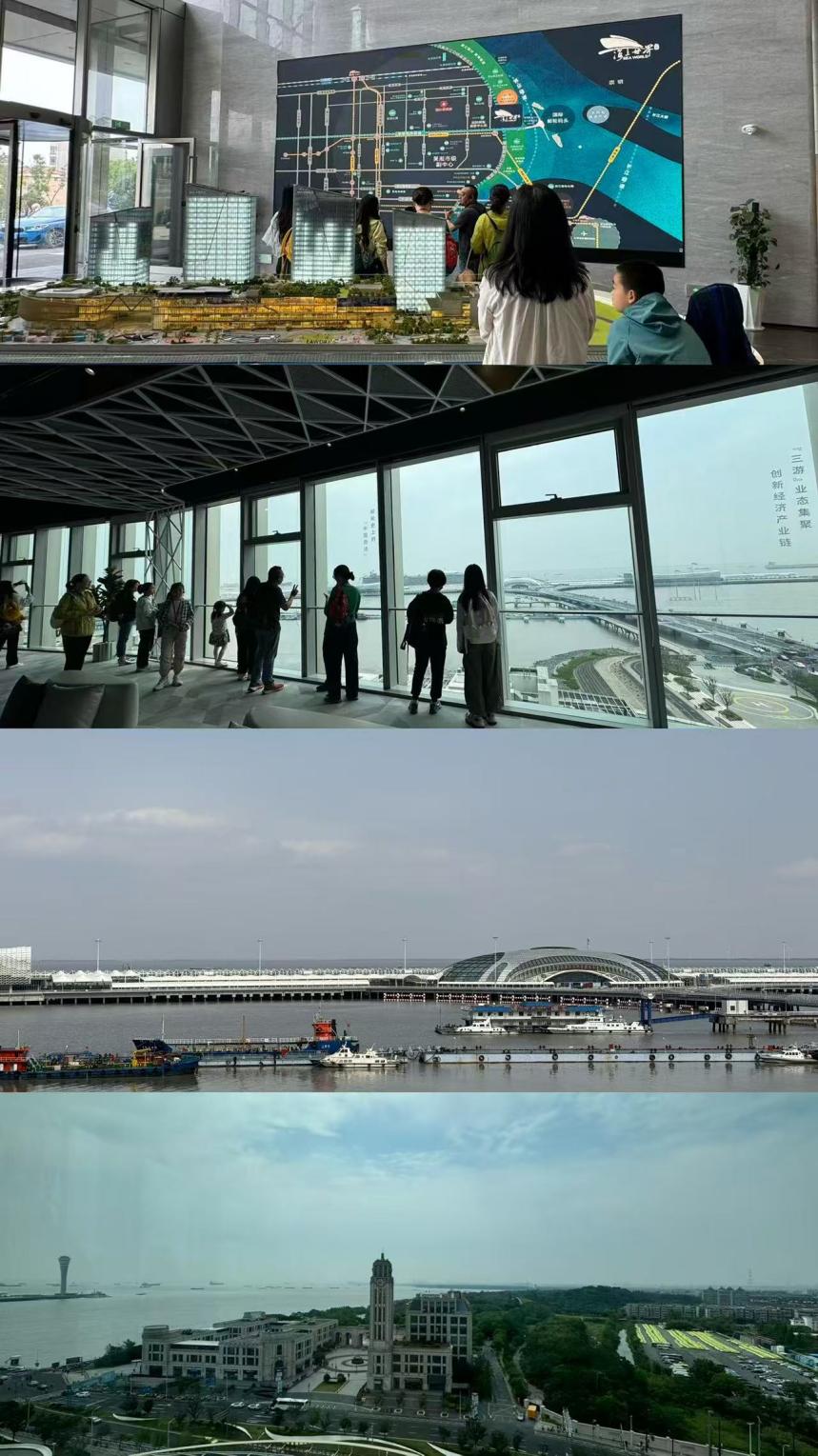
Baoshan Binjiang
In the eyes of Shanghai people
Speaking of Baoshan, it is a steel heavy industry area
During the "Thirteenth Five-Year Plan" period, Baoshan's development relied on the Binjiang area
The core goal is to develop the "three tours" industry of cruise, yachts and cruise ships
Use "waves" to replace the "steel flowers" in people's inherent impressions
Build a world-class international cruise home port
Focus on cultivating the cruise industry chain
Disney in the east, DreamWorks in the south
There is Dahongqiao in the west and Cruise City in the north
Build a world-famous cruise city
Baoyang Road Chongming Passenger Terminal-Cruise Port Land Passenger Transport Center
Baoyang Road Enclosed Plot--Waterfront Vitality Center
Baosteel-Green Business Center, South of Baoyang Road
"Wusong Culture" is the second business card developed by Baoshan Riverside
Build ecological cultural corridor along the coast
It will become an important window for Shanghai to build a world-famous tourist city
The materials in the article come from: Shanghai Huangpu, Shanghai Xuhui, Shanghai Hongkou, Yangpu Xiaolintong, News Morning News, Shanghai Headline, and Internet.
Click "Write a message" in the lower right corner to leave your opinion
More tasting and benefits!
Check out Xiaobian's circle of friends!
long press to identify the QR code
They are all waiting for you
")
")
还没有评论,来说两句吧...